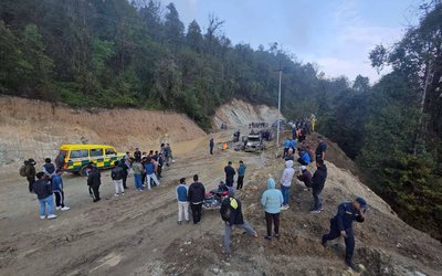
Even after almost 12 hours, the efforts are yet to be made to release water of Kaligandaki which was blocked following a massive landslide along Baishari of Bhagwati VDC along Beni-Mustang high way, 500 kilometer west of capital Kathmandu.
As experts are yet to recommend outlet the water, the depth and length of the lake is expanding. Nepal Army has already sent a team of expert in the region. With the level of water is rising, Ministry of Home Affairs have already issued warning along with the settlement in Myagdi, Baglung, Parbat,Syanja, Gulmi, Palpa and Nawalparasi.
As any overflow of water may cause damage to Kali Gandaki Hydropower project, Nepal Electricity Authority is also monitoring the events.
According to District Administrative Office Baglung, the site of landslide lies at 8 km above Beni, the district headquarters of Myagdi. As it might pose danger to the locals, we're moving them to safer locations," said chief district officer. "I've requested Army helicopter from Kathmandu. They'll arrive soon after dawn." expect many landslides in the high Himalaya of northern Nepal, where valley floor elevations exceed c. 800 m.
These areas are particularly important because they have very long, steep slopes and narrow valleys, so that large landslides are likely to block valleys (see section on ‘Landslide dams’ below).
Geologists have been issuing a warning that the valleys of the Kali Gandaki, Marsyagndi, Trisuli, and Sun Kosi rivers, and their major tributaries, are at greatest risk, but large valley-blocking landslides are also likely elsewhere.
These areas also have little space for roads, so are likely to be cut off with overland access taking days (to weeks). As earthquake has already shaken the mountains, the flood and landslide will likely to wipe out number of villages in coming days.
- TEACHERS ON STRIKE: Students' Future In Jeopardy
- Apr 25, 2025
- NEPAL-THAILAND: Joint Business Council
- Apr 13, 2025
- BIMSTEC SUMMIT: Nepal’s Stand
- Apr 11, 2025
- IME GROUP: Expands Into Paper Industry
- Mar 24, 2025
- CPN UML: Instigated By India
- Mar 23, 2025


