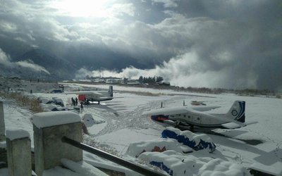
There will be partly to generally cloudy in the western region along with eastern and central hilly regions and partly cloudy in the rest of the country. According to Meteorological Forecasting Division, thunderstorm accompanied with gusty winds/lightning likely to occur at some places of the western region and of the eastern hilly region , isolated brief rain is possible at one or two places of the central hilly region.
With Extremely Severe Cyclone Fani gearing up for landfall at Odisha coast and West Bengal, Meteorological Forecasting Division alerted to watch the rainfall across Nepal particularly the possibility of snow fall in central and eastern Himalaya. Fani after making landfall near Puri district on May 3, would move north-northeast through and through Gangetic West Bengal.
However, by the time Fani would reach West Bengal, it would have weakened into a cyclonic storm only. Although it will weaken further when it will enter to land but it will bring some rains.
As it will land on May 3 in Odisha Coast, on May 4 Fani would have moved further north towards West Bengal and weakened as well. Thus, the weather over Odisha would improve.
The intensity and spread of rains will remain on the lower side on May 2. Beginning Friday, West Bengal including state capital of Kolkata would start witnessing heavy to very heavy rains. As Fani reaches North Coastal Odisha, some parts could also witness extremely heavy rainfall.
These showers would be accompanied with squally winds to the tune of 70 kmph - 80 kmph gusting up to 100 kmph.
By May 5, the cyclonic storm Fani will lose its strength and also move towards Bangladesh. As a result, weather will gradually start clearing up over the entire state.
- Global IME Bank Provides 20 Lakh Rupees Support For Construction Of Electric Crematorium In Kohalpur
- Nov 28, 2024
- More Laws Should Be Amended To Create An Investment Environment: President Dhakal
- Nov 28, 2024
- Masato Kanda Elected as ADB President
- Nov 28, 2024
- Displaced Lebanese return home as ceasefire begins
- Nov 28, 2024
- Weather Forecast: Patly Cloudy And Mainly Fair In Madhesh, Lumbini, Kanali And Sudur Paschim Provinces
- Nov 28, 2024


