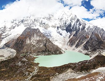
Out of 2,979 water bodies mapped during the recent Bhutan glacial lake inventory, 567 within the four river basins are classified as glacial lakes, of which 17 are potentially dangerous.
Covering an area of 0.14 percent and constituting 19.03 percent of the water bodies in the country, all glacial lakes in Bhutan are between 4,062 metres above sea level (masl) and 5,507masl, with larger glacial lakes located between an elevation band of 5,000masl.
According to the survey, Phochu sub-basin has the highest number of glacial lakes (157), of which nine are potentially dangerous. Thorthomi is the largest glacial lake, which lies in the headwater of the Phochu basin with a surface area of 4.20km2.
With only nine, Dangmechu has the least number of glacial lakes. Wangchu basin has 13 glacial lakes that are in stable condition, the survey report says.
These findings recently published by the National Centre for Hydrology and Meteorology (NCHM) defies the two-decade old belief that the country has more than 2,500 glacial lakes and over 20 potentially dangerous glacial lakes.
In the latest criteria set by NCHM, a lake that falls above the elevation of 3,500masl and not more than two kilometres from glaciers are considered glacial lakes. In the past, the criteria set by the International Centre for Integrated Mountain Development, all lakes above the elevation of 3,500masl were considered glacial lakes.
An official with NCHM said that the difference in the current and past inventories were caused by additional criteria to define glacial lakes and the use of different base materials with differing resolution and techniques in the current inventory.
The data for the survey was collected using satellite images and remote sensing techniques.
The updated inventory is expected to serve as the primary source of information for scientific studies and as a basis for socioeconomic developmental planning in the country.
The report states that most glacial lakes in Bhutan are erosional which means the lakes are formed after glacier retreat and detached from mother glacier.
Due to climate change impacts, studies indicate that glaciers in high mountain regions are experiencing accelerated retreat rate. As a result of higher precipitation in the eastern Himalayan region in which Bhutan falls, the country’s glaciers face a higher recession rate.
The presence of active glaciers in the country has also resulted in the formation of new lakes, expansion of existing supra glacial ponds, and increase in water level in the proglacial lakes.
The risk from glacial lakes downstream is ever-present. According to records, Bhutan has experienced a total of 21 Glacial Lake Outburst Floods.
Source: Kuenselonline
- Myanmar Government says quake death toll tops 2,700, could rise further
- Apr 02, 2025
- Trump To Reveal Reciprocal Tariffs On Wednesday
- Apr 02, 2025
- UN migration agency calls for support for quake-hit Myanmar
- Apr 01, 2025
- KMC Imposes Rs 793,000 Fine On Former King Shah
- Mar 30, 2025
- US proposed new mineral rights deal: Zelenskyy
- Mar 30, 2025


